
NIST INSIGHT Builds Indoor Maps First Responders Can Query Before a Call
NIST’s INSIGHT research turns building scans into structured indoor scene graphs for pre-incident planning, with human review still central to operational use.
On this page
An emergency plan is only useful if it reflects the building responders will actually enter. NIST’s INSIGHT project explores how scans and structured scene representations could help make indoor information searchable across systems. The announced use is pre-incident planning—a way to prepare—not a claim that an autonomous system is already guiding crews through a live incident.
From scans to a structured scene
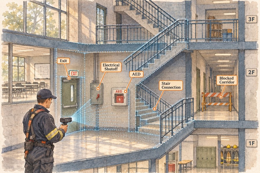
NIST describes INSIGHT as building interoperable indoor maps from point-cloud and building information. Rather than leaving a scan as a dense collection of points, the system organizes objects and relationships into a scene graph: spaces connected by doors, stairs, corridors and safety features. This structure can make a question such as “where is the nearest exit from this room?” easier to express than searching a raw point cloud. [1]
The research paper frames the problem as indoor scene graph generation and reports work on recognizing and connecting objects in building environments. NIST’s announcement emphasizes interoperability, including established indoor and building data models. [2]
That translation is consequential. A map that can be imported into existing systems is more useful than a one-off visualization, but compatibility does not automatically make the content current or accurate. A building can change after a scan: a door may be locked, a corridor obstructed, or equipment relocated.
A planning aid, not a live dispatch layer
NIST describes the near-term purpose as pre-incident planning, where building information can be prepared for responders ahead of an emergency. The agency says future work could bring live location tracking into the system. That distinction should stay explicit: an advance map and a live navigation service have different data, timing and reliability requirements. [1]
For pre-planning, a structured map may help teams identify routes, stairs, exits, utility shutoffs and other relevant features before a call. The practical value depends on whether the source data is available, whether important objects are recognized correctly, and whether local responders can review and update the result.
The research also sits within a broader standards landscape. IndoorGML is an Open Geospatial Consortium standard for describing indoor spaces and navigation relationships. Using common representations can help data move between tools, but it cannot resolve disagreement about which source is authoritative or whether a feature remains present. [3]
Verification is part of the product
A generated map should carry its provenance: when and how the building was scanned, which records were used, which features were inferred, and who verified them. Uncertain or low-confidence areas should be visible. Safety-critical decisions should be checked by people familiar with the facility, with an update path when construction or operations change.
That review can turn an AI-generated representation into a useful planning artifact. Without it, a crisp visual may create more confidence than the underlying data deserves. A digital map should not imply certainty about a blocked exit, a locked stairwell or the location of equipment that was moved after capture.
What to watch next
The next evidence to look for is operational: how quickly maps can be updated, how errors are surfaced, how teams validate safety features, and whether the data can be maintained across building owners and response agencies. NIST’s announcement describes a research direction, with real-time tracking still a future possibility.
The project’s key contribution may be the bridge between scans and structured, portable indoor knowledge. For responders, that bridge will be valuable only if its endpoints stay current, interpretable and verified.
Frequently asked questions
Is INSIGHT a live navigation system for responders?
NIST describes INSIGHT as supporting pre-incident planning and says future work could add real-time tracking. The announcement does not establish that live tracking is already deployed.
How are indoor maps created?
The research uses building information and point-cloud data to create structured scene representations that can capture spaces and safety-relevant features. The process and resulting map need review before operational use.
Can a generated map replace a building inspection?
No. A generated representation can help organize and query information, but responders and facility staff must verify critical details such as access, exits and hazards against current site conditions.
Sources & further reading
Keep reading

NIST’s Federated-Learning Testbed Puts Privacy Claims on a Measurable Track
NIST compares federated learning and differential privacy on soybean genomic data, while showing that local records do not guarantee privacy.

OpenAI's 948 Linux Findings Are a Pipeline Result, Not 948 New CVEs
OpenAI says its research pipeline reproduced many Linux kernel flaws and generated candidate patches. The disclosure count still needs careful interpretation.

Palantir's 96% Growth Has a New Mix. The Customer Numbers Need More Context
Palantir's Q3 revenue topped $2.3 billion, with U.S. commercial sales passing government revenue. Growth is striking, but deal counts are not recurring revenue.
/* Comments */
Comments are offline right now — we reconnect automatically, nothing is lost.